
A land shaped by migration and the river
The Volta Region as it exists today was formed from the former British Togoland, part of the German protectorate of Togoland that Britain administered as part of the Gold Coast and later renamed Trans-Volta Togoland. Its people are mostly Ewe — around two-thirds of the population — alongside Guan, Akan and other groups, and the region's 18 districts are administered from Ho.
Ewe oral history places the great migration at Notsie in present-day central Togo, in the later seventeenth century. The story is told with unusual vividness: a king, Agorkoli, ruled harshly behind a great sacred wall, and the people escaped by softening a section of it with water until an elder, Tegli, pierced it and led them out, walking backwards so they could not be followed. The Anlo Ewe settled the westernmost end of that dispersal, on the coast and around the lagoon, and their name is said to come from the founder Atsu Wenya's words of reluctance to move on — me nlo, I have folded myself up.
That coastal settlement shaped everything that followed. The Anlo built a decentralised but organised polity, with a king, the Awoamefia, chosen in rotation from two royal clans, and a three-wing military structure borrowed in part from Akwamu. The lagoon gave them fish, salt and reeds; the sea gave them trade, and eventually gave them the slave trade as well.

Forts, markets and the memory of the slave trade
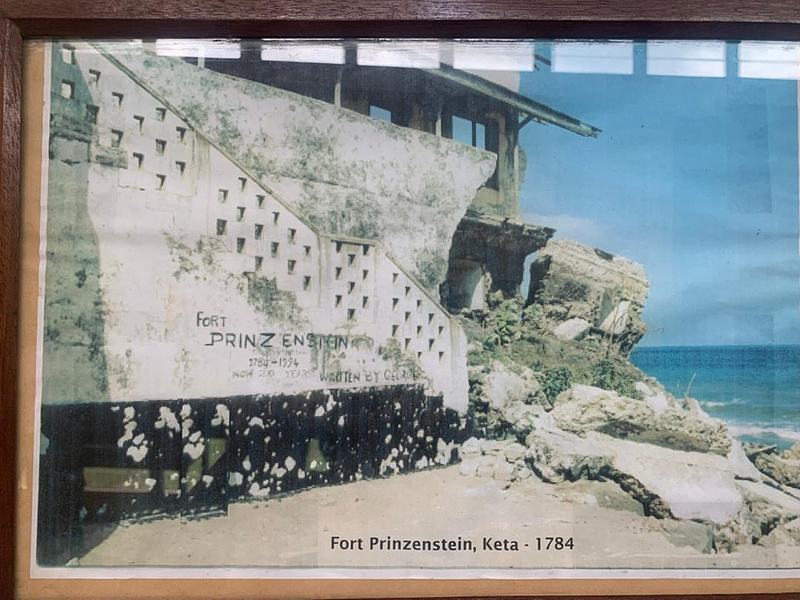
Fort Prinzenstein at Keta is the region's most sobering site. Built by Danish traders in 1784 after the Sagbadre War against the Anlo Ewe, it is one of the few such forts east of the Volta River, and it was used as a dungeon for enslaved people awaiting transportation to the Caribbean until 1803. Captives were marched from the interior to markets at Keta and Atorkor, examined and branded, then held here. The fort passed to Britain in 1850 with the rest of the Danish Gold Coast, later served as a prison, and was partially destroyed by the sea in 1980. It is inscribed, with Ghana's other forts and castles, as a UNESCO World Heritage Site.
Atorkor, a fishing village on the Atlantic, was part of what was known as the Upper Slave Coast. A memorial raised in 1999 stands in a high-walled circular enclosure: a life-size group of a European slave-trader with a whip above two kneeling, chained African figures, with a frieze narrating the local story of a white trader who deceived villagers into slavery. It is not an easy place, and it is not meant to be. Visit quietly, and let the people who keep these sites tell you what they mean.

Mountains, waterfalls and the highest villages
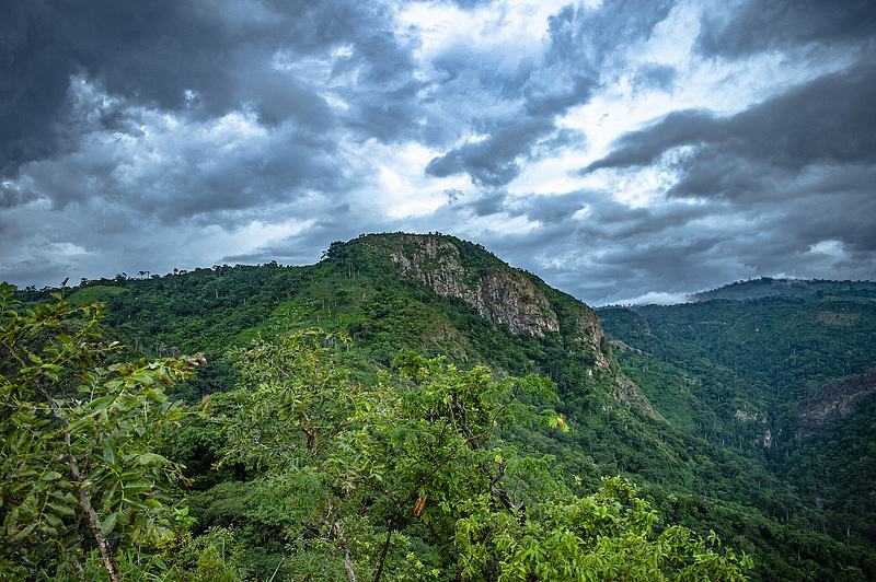
Inland, the Agumatsa Range lifts the region into another climate. Mount Afadja, known to Ewe speakers as Afadjato, sits near the Togo border above the villages of Liati Wote and Gbledi Gbogame. Its summit is often quoted at 885 metres, though the figure is disputed and the true height is closer to 587 metres; either way, the climb is the region's signature walk, through forest that shelters monkeys, more than 33 species of mammals and around 300 butterfly species. The name itself carries a story — afar, dja and to, war, plant and mountain — of ancestors who fought off wild animals and were halted by an itching plant on the slopes.
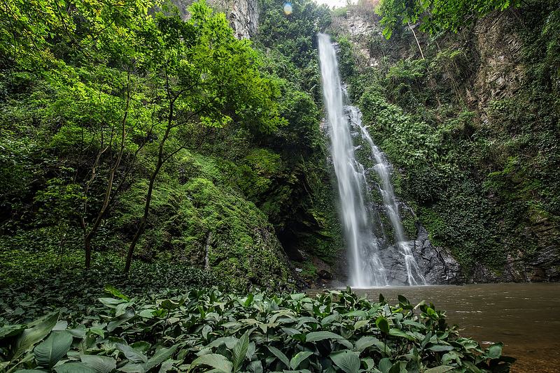
Wli Waterfalls, also called Agumatsa Falls, is the highest in Ghana and the tallest in West Africa, formed where the Agumatsa River pours over sandstone and shale cliffs in the Agumatsa Wildlife Sanctuary. The lower fall is a flat walk; the upper fall is a steep, often slippery climb. Hunters are said to have found the falls by following a sound they took for a talking drum.
Higher still, Amedzofe sits at the foot of Mount Gemi in the Avatime Hills, among the highest settlements in Ghana, with a German-built church and a large cross on the summit erected by missionaries. Its Ote Falls, canopy walkway and sacred caves make it a natural base for a day or two of cool air and long views.

The lagoon coast: birds, salt and a changing shoreline
The Keta Lagoon is the largest lagoon in Ghana, a brackish water body separated from the Gulf of Guinea by a narrow sandbar and, with its surrounding wetlands, forming the Keta Lagoon Complex Ramsar Site, designated in 1992. It is the most important waterbird site on the Ghana coast: 76 waterbird species have been recorded, with a total population estimated at well over 100,000, including globally significant numbers of 21 species and almost a third of the East Atlantic Flyway population of spotted redshank. The Fiahor, Woe, Tegbi, Adina and Afiadenyigba sections matter most for birds.
The lagoon is also a working landscape. Fishing, salt winning, reed harvesting and shallot farming sustain the communities around it — the area is Ghana's foremost shallot-growing district — and the Anlo have long held spiritual obligations to the water, with rituals performed for a good catch. The coast itself is one of the most severely eroded in the region, and the Keta Sea Defence project has reshaped the shoreline; the fort at Keta stands as a reminder of how much has already been lost. Sea turtles nest on the Fuveme to Anloga stretch, and community projects at Dzita and elsewhere let visitors see conservation work up close.

What to do
Things to do in Volta
-
Attraction
1.Walk to Wli Waterfalls
The Agumatsa River drops in two stages inside the Agumatsa Wildlife Sanctuary, and the lower fall is the region's most rewarding easy walk — a mostly flat forest trail with pools at the base and thousands of fruit bats roosting on the cliffs above. The upper fall is a far steeper, longer climb for those with the stamina and the right footwear.
Tip: Time your return from the lower falls for late afternoon, when the bats lift off the cliffs to feed.
-
2.Climb Mount Afadja (Afadjato)
Ghana's best-known summit trail starts at the community reception centre in Liati Wote and climbs through forest on the Agumatsa Range towards the Togo border. Guides are arranged locally, and the walk rewards you with ridge views over the Volta landscape. The mountain's name comes from Ewe words for war, plant and mountain, and the slopes hold monkeys, butterflies and a plant that causes fierce irritation.
Tip: Start early to climb in cooler air, and keep to the path — the irritating plant on the mountainside is best avoided.
-
3.Extend the hike to Aduadu Mountain
Aduadu, at roughly 746 metres, lies about 3.5 kilometres east of Mount Afadja and is usually walked as an extension of the Afadja summit trail. It is quieter than the main peak and gives a different angle on the Agumatsa Range and the border country. Treat it as a full-day outing with a local guide rather than a quick add-on.
Tip: Arrange the extension at the reception centre before you set off, so your guide knows your pace and turnaround time.
-
4.Amedzofe: canopy walkway, Ote Falls and Mount Gemi
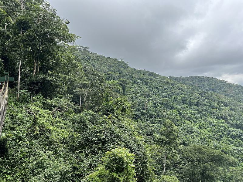
Amedzofe sits high in the Avatime Hills at the foot of Mount Gemi, among Ghana's highest settlements, with cool air and long valley views. The suspended canopy walkway above Ote Falls is reached by a steep guided trail of concrete steps, and the town's German missionary church and hilltop cross add a layer of nineteenth- and twentieth-century history to the walk.
Tip: The steps to the canopy walkway are steep and can be slick after rain; take it slowly and wear shoes with grip.
-
5.Fort Prinzenstein, Keta
Built by Danish traders in 1784 after the Sagbadre War, this partly ruined fort is one of the few such structures east of the Volta River and part of Ghana's UNESCO-listed forts and castles. It served as a dungeon for enslaved people bound for the Caribbean until 1803, later as a prison, and was damaged by the sea in 1980. Come to learn, not to tick off.
Tip: Read up on the fort's history beforehand so you can ask informed questions of whoever guides you on site.
-
Attraction
6.Atorkor Slave Trade Memorial
In the coastal village of Atorkor, a 1999 memorial marks the area's role as a port on the Upper Slave Coast. Inside a high-walled circular enclosure, a life-size sculpture shows a European slave-trader with a whip over two kneeling, chained African figures, and a frieze tells the local story of villagers deceived into slavery. It is a place for silence and reflection.
Tip: Combine it with Fort Prinzenstein at Keta, about 28 kilometres away, to understand how captives moved from market to fort to ship.
-
Attraction
7.Birdwatching on the Keta Lagoon
The Keta Lagoon Complex Ramsar Site is the most important waterbird site on the Ghana coast, with 76 recorded species and a population estimated at well over 100,000, including waders that migrate along the East Atlantic Flyway. The Fiahor, Woe, Tegbi, Adina and Afiadenyigba sections are the richest for birds, and boat access reaches the breeding islands.
Tip: The Forestry Commission notes the site is not yet fully developed for visitors, so arrange boats and guides locally in advance.
-
Attraction
8.Kente weaving at Kpetoe
Kpetoe, on the Ho–Aflao highway near the Togo border, has produced Ewe kente for generations and is known for cloth that is distinctive in design. The local weaving centre is a roofed, open-air building where up to 25 weavers work and display their cloth, and the neighbouring village of Abenyinase has more weavers selling outdoors. Expect to bargain, and to enjoy doing it.
Tip: Weavers generally do not work on Sundays, and the annual Agbamevo Za kente festival is held each August in Kpetoe.
-
Attraction
9.Agbozume cloth market
Agbozume's four-day periodic market is the wholesale heart of Ewe kente, drawing buyers from across the region and beyond. It is a working market rather than a staged attraction, which is exactly its appeal: bolts of cloth, traders calling, and the chance to see how the fabric moves from loom to buyer. Go with patience and a sense of humour.
Tip: Markets run on a recurring cycle rather than daily, so check the market day locally before you travel out.
-
Attraction
10.Cape St. Paul Lighthouse, Woe
This red-and-white metal lighthouse was built in 1901 on the beach at Woe, between the Keta Lagoon and the Atlantic, and is reported to be the oldest in the country. It still functions, guiding ships away from what is believed to be a submerged mountain offshore. Climbing it is a slightly daunting adventure with fine views of the sandy coast and farmland.
Tip: Ask locally before climbing, and keep well back from the surf — this stretch of coast is eroding fast.
-
Attraction
11.Sea turtle conservation at Dzita
The Fuveme to Anloga beach stretch is one of Ghana's main sea turtle breeding areas, used by leatherback, green and olive ridley turtles. Community-linked conservation and viewing sites along the Anlo-Keta coast, including at Dzita, work with local fishermen to protect nests and give visitors a chance to see the work — and, in season, the turtles themselves.
Tip: Nesting runs roughly September to March; go with a community guide and keep lights and noise to a minimum.
-
Attraction
12.Boat the Anyanui channel towards Ada Foah
Motorised boats run the roughly seven-kilometre Anyanui Channel, a Volta River distributary in the Anloga District, threading mangroves and sandy banks towards the Volta estuary at Ada Foah. It is a slow, low-angle way to see the lagoon country and the river mouth, and a good counterpoint to the forest walks inland.
Tip: Arrange the boat and a life jacket locally in Anyanui, and agree the route and return time before setting out.


Plan your time
Suggested itinerary
Half a day: Keta's history and the lagoon
Start at Fort Prinzenstein in Keta, where the Danish fort and its dungeon tell the story of the slave trade east of the Volta. Walk the beach behind it, then drive the short distance to Atorkor for the 1999 slave trade memorial. Finish with an hour on the lagoon shore at Woe or Tegbi, looking for waders and herons, and climb the 1901 Cape St. Paul Lighthouse if it is open.
Fort Prinzenstein→Atorkor Slave Park→Cape St. Paul Lighthouse→Keta Lagoon Birdwatching
One day: mountains and waterfalls
Begin at the Afadjato-Tagbo Eco-Tourism Reception Centre in Liati Wote and climb Mount Afadja with a local guide, continuing to Aduadu Mountain if you have the legs for it. After lunch, drive to Wli and take the flat forest trail to the lower Agumatsa falls, staying for the late-afternoon bat flight. If time allows, add the steep climb to the upper falls — but only with proper footwear and daylight to spare.
Afadjato-Tagbo Eco-Tourism Reception Centre→Aduadu Mountain→Agumatsa Wildlife Sanctuary
Two days: highlands, kente and the coast
Day one: climb Mount Afadja and walk to Wli's lower falls, then overnight in the Hohoe or Liati Wote area. Day two: drive south to Amedzofe for the canopy walkway, Ote Falls and the Mount Gemi views, then continue to Kpetoe to watch kente being woven and buy cloth. If you are heading for the coast, push on to Agbozume for the periodic market or to Keta for the fort and lagoon before dark.
Afadjato-Tagbo Eco-Tourism Reception Centre→Agumatsa Wildlife Sanctuary→Amedzofe Canopy Walkway→Agortime-Kpetoe Kente Town→Agbozume Market→Fort Prinzenstein

Seasons and festivals
When to go
The region has two broad characters. Inland, Wli is open year-round, but the falls are at their most powerful from April to October, when the water thunders into the pool below; the upper falls hike is normally too slippery and treacherous during the rainiest months. The dry season from November to March brings clearer water and easier access on the trails. On the coast, the Keta area is one of the driest along Ghana's shoreline, with annual rainfall under 1,000 mm, a main rainy season from March to July and the lowest rainfall around September and November. Sea turtle nesting on the Fuveme to Anloga stretch runs roughly September to March, and the harmattan months of November to February are when the shallower parts of the lagoon evaporate and salt crystals form near Adina, Afiadenyigba and Anyako.
- Agbamevo Za (Kente Festival), Kpetoe · August, dates vary by year
- A week-long kente festival in Kpetoe featuring speed-weaving contests and kente dress design competitions, alongside other cultural activities. Dates vary, so confirm the current year's programme with the Ghana Tourism Authority before travelling.
- Deza (Palm) Festival, Dzodze · Annual
- Dzodze, the Anlo-Ewe administrative capital of Ketu North Municipal District, is known for palm cultivation and holds an annual Deza, or Palm, Festival celebrating that heritage.
- Hogbeza, Dugame-Battor · Annual
- The Battor Traditional Area in North Tongu District, one of eight traditional areas in the district, is known for its migration history and holds the annual Hogbeza festival at Dugame-Battor.
Access
Getting there and around
Ho, the regional capital, is the natural hub. Ho Airport is operated by Ghana Airports Company Limited and opened to commercial traffic in December 2021, though scheduled services have been suspended since March 2022, so most travellers arrive by road. From Accra, the main routes run east and north-east towards Ho and Hohoe; Wli is about 280 kilometres from the capital, and the falls sit roughly 20 kilometres from Hohoe, reached by turning off the main road and continuing a short distance to the visitor centre at the edge of the village. Trotros run these roads frequently.
On the coast, Keta, Denu and Aflao sit along the eastern seaboard, with Aflao forming the border with Togo. Kpetoe lies on the main Ho–Aflao highway, with frequent public transport in both directions. Around the lagoon, boats are arranged locally — for the Anyanui channel and for reaching the bird islands — and the Forestry Commission notes that the Ramsar site is not yet fully developed for visitors, so plan boat trips and guides in advance rather than expecting to turn up and find them. Within the highlands, trailheads such as the reception centre at Liati Wote and the Wli visitor centre are where you arrange guides; walking is the only way to reach the falls and summits.
Good to know
Before you go
Bring sturdy footwear with grip for the highland trails: the climb to Wli's upper falls and the steps to the Amedzofe canopy walkway are steep and can be slippery after rain. Carry water, sun protection and a light rain layer, and start hikes early to avoid the heat. On the coast, the sun is fierce and the surf can be dangerous; swim only where locals tell you it is safe, and never near the eroding stretches around Keta.
Guides are essential rather than optional at most sites, and they are usually arranged at community reception centres or visitor centres — use them, and pay them properly. At Fort Prinzenstein, the Atorkor memorial and the lagoon's sacred sites, dress and behave with restraint, ask before photographing people or ceremonies, and follow local guidance about where not to walk. Bargaining is normal in markets and at weaving centres; do it with good humour. Finally, this is a coast under real climate pressure, so treat the shoreline, the lagoon and the people who depend on them with care.

FAQ
Questions travellers ask about Volta
Where is the Volta Region in Ghana?
It lies in the east of the country, bordered by Togo to the east and with Lake Volta and the Volta River forming much of its western edge. Ho is the regional capital, and other major towns include Hohoe, Keta, Anloga, Aflao, Sogakope and Denu.
Is Wli Waterfalls really the highest in West Africa?
It is widely described as the highest waterfall in Ghana and the tallest in West Africa, with the upper fall dropping roughly 80 metres. It is formed by the Agumatsa River flowing over sandstone and shale cliffs in the Agumatsa Wildlife Sanctuary.
How hard is the Mount Afadja hike?
It is a steady forest climb rather than a technical one, usually done with a local guide from Liati Wote, and it can be extended to Aduadu Mountain about 3.5 kilometres east. Note that the frequently quoted 885-metre height is disputed; the summit is closer to 587 metres.
When is the best time to see the Keta Lagoon's birds?
The lagoon is the most important waterbird site on the Ghana coast, with 76 recorded species and a population estimated at well over 100,000, including migratory waders. The Fiahor, Woe, Tegbi, Adina and Afiadenyigba sections are the richest, and the site is not yet fully developed for visitors, so arrange boats and guides in advance.
Can I see sea turtles in the Volta Region?
Yes. The Fuveme to Anloga beach stretch is one of Ghana's main sea turtle breeding areas, used by leatherback, green and olive ridley turtles, with nesting roughly from September to March. Go with a community conservation guide and keep noise and lights to a minimum.
Where can I buy kente cloth in the Volta Region?
Kpetoe, on the Ho–Aflao highway, is the best-known weaving town, with a weaving centre where up to 25 weavers work and sell, and more weavers in the neighbouring village of Abenyinase. Agbozume's four-day periodic market is the wholesale hub for Ewe kente.
Do I need a guide to visit the waterfalls and mountains?
Yes, in practice. Guides are arranged at community reception centres and visitor centres, such as the Afadjato-Tagbo Eco-Tourism Reception Centre at Liati Wote and the Wli visitor centre, and they are the people who know the trails, the conditions and the local protocols.
Sources for this guide (13)
- Volta Region — Wikipedia
- Anlo Ewe — Wikipedia
- Keta Lagoon — Wikipedia
- Fort Prinzenstein — Wikipedia
- Mount Afadja — Wikipedia
- Wli waterfalls — Wikipedia
- Ho Airport — Wikipedia
- Wli Waterfalls — Visit Ghana
- Kpetoe Kente Weaving Village — Visit Ghana
- Keta Lagoon Complex Ramsar Site — Forestry Commission
- Safeguarding the Keta Lagoon Complex Ramsar Site — Satoyama Initiative
- Forts, Museums & Historical Sites — Access Volta Region
- Atorkor Slave Trade Memorial — Contemporary Monuments to the Slave Past
Written September 29, 2026 from these sources and reviewed by the VisitGhana.app team. Confirm practical details locally before travelling.


