
The cradle of the Bono
Long before Ghana was a country, this was the heartland of Bonoman, the first centralised Akan state. Its capital, Bono Manso, sits about 17 km north-east of Techiman on the Techiman–Kintampo road, founded in the 14th century and tied to the long-distance gold trade. Archaeological work suggests that at its height in the 16th and 17th centuries the capital covered roughly 230 hectares and supported as many as 10,000 people — one of the largest communities in precolonial West Africa. Asante conquered Bonoman in 1722–23, and the seat of the Bono state later moved to Techiman.
The Bono people trace their origins to a sacred cave called Amowi, and the Tanoboase Sacred Grove is remembered as one of their migration destinations. The grove wraps around a massive inselberg, an isolated rock outcrop riddled with caves that sheltered the area's earliest inhabitants and later served as refuge during the Bono–Asante wars of the 18th century. Because the site is sacred, no farming or development has been allowed on or near it, and it survives as one of the few patches of primary forest left in the region.

A river, a shrine, a scar
Techiman is the heartland of one of the most revered Akan religious institutions: the worship of the Tano River, the longest river running through the Akan region of Ghana. Veneration of the river probably predates Bonoman itself. Its source lies near Tanoboase, about 12 km north-east of Techiman, and the Techiman area alone is home to no fewer than 175 Tano shrines. The senior Tano deity, Taa Kora, is associated with that source; all Tano abosom are regarded as children of Nyame. Rituals are performed at the river's source and at a shrine in a cave within the Tanoboase grove, and the river's fish are protected because of the water's sacred nature. These places are open to visitors, but permission must be sought from their custodians.
There is a harder history here too. Bono Manso was identified in the early 2000s as the site of a major slave market, and memorial gardens for Martin Luther King Jr., Marcus Garvey and Malcolm X were built there to commemorate the trans-Atlantic slave trade. It should be said plainly that the evidence for the slave-market claim is thin — the identification was made by the tourism industry rather than by archaeology. Further north, the Kunsu slave caves in the Kintampo North Municipality are linked by oral tradition to the trade, remembered as holding places from which captives were moved on. Visit these sites slowly, and with respect for the communities who keep their memory.

Where forest becomes savannah
Bono East is a region of transition. Its vegetation is predominantly forest with fertile soils, and the woodland savannah zone around Techiman, Yeji, Nkoranza, Kintampo, Kwame Danso and Prang produces yam in quantity, alongside beans, maize, cassava, cocoyam, rice and plantains. Along the region's stretch of Lake Volta, fishing is a way of life.
The climate runs to a dry season from December to April and a wet season from roughly July to November, with average annual rainfall of 750 to 1050 mm. The hot Harmattan wind blows down from the Sahara between December and early February, dry and dusty. Temperatures swing widely — as low as about 14°C at night and up to about 40°C by day. The waterfalls are seasonal: the Pumpum's flow peaks in the rains from May to October, while the dry months bring clearer water and easier access. Most people here speak the Bono dialect, and Bono ancestral worship and Christianity shape the region's spiritual life side by side.

What to do
Things to do in Bono East
-
1.Kintampo Waterfalls
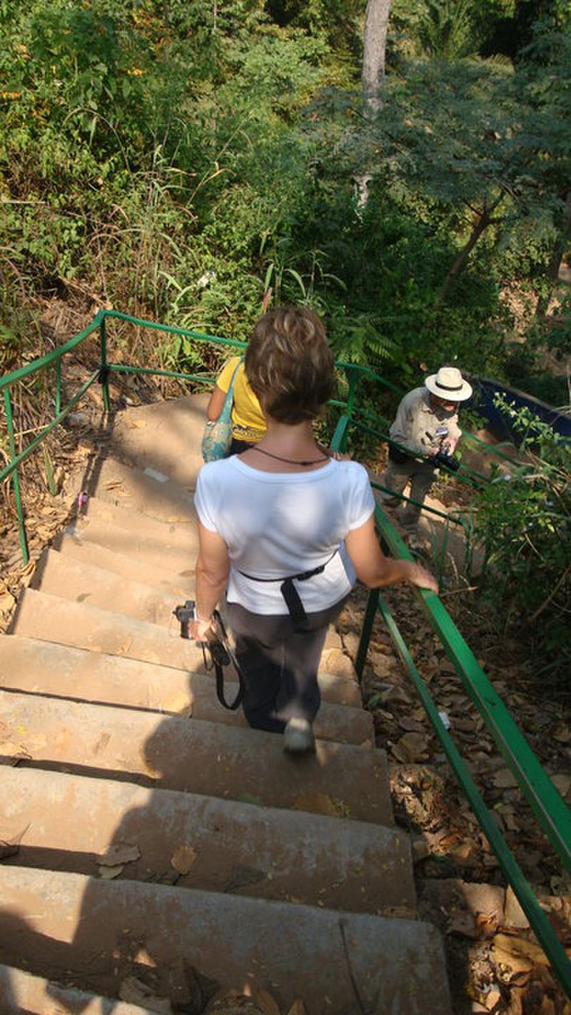
The region's signature sight: a three-drop waterfall on the Pumpum River, a tributary of the Black Volta, about 4 km north of Kintampo on the Kumasi–Tamale road. The longest single drop is around 25 metres, and after steps and cascades the river falls roughly 70 metres in total. Known as Sanders Falls in colonial days, it was designated a tourism site in 1992. There is a cave behind the falls housing a colony of bats, and a rock where Kwame Nkrumah is said to have sat to read and meditate.
Tip: The third stage has around 173 steps down and 151 up — wear shoes with grip, as the rock surfaces are slippery. Swimming is permitted only at the base of the falls, not at the upper stages.
-
2.Kintampo Canopy Walkway
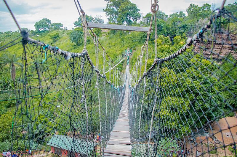
A suspended walkway strung across the river overlooking the Kintampo waterfall, added when the site was redeveloped after a 2017 accident in which a falling tree killed 18 people. The falls were closed for a safety and security assessment and reconstruction, and the canopy walkway was built before the site reopened in 2019. It gives a different, airborne view of the gorge and the forest that hides the falls.
Tip: Combine it with the waterfall visit in a single stop — the walkway sits at the same site, so there is no extra journey.
-
Attraction
3.Tanoboase Sacred Grove
A sacred grove and rock shrine near Tanoboase, wrapped around a huge inselberg filled with caves. It is remembered as one of the migration destinations of the Bono people after they left the caves at Amowi, and as a place of refuge during the Bono–Asante wars. Because it is sacred, no farming or development has been allowed here, leaving rare primary forest. A shrine associated with the Tano River sits in a cave within the grove.
Tip: Tours exploring the grove's history and ecology run throughout the year. Ask permission from the custodians before approaching the shrine itself.
-
Attraction
4.Kristo Buase Monastery, Tanoboase
A working Benedictine monastery between Tuobodom and Tanoboase on the Techiman–Kintampo road, founded by Prinknash, Ramsgate and Pluscarden Abbeys on land given to the Catholic Church in the 1970s by the Tanoboasehene. Designed by a Paris-based architect and built in the late 1980s, it opened in 1989. Its setting is striking: rock formations linked to the Tanoboase inselberg, with a natural rock bridge, and caves that sheltered early inhabitants long before the Bono state existed.
Tip: The Benedictine brothers welcome visitors and host retreats through the year. It is a working religious house, so dress and behave accordingly.
-
Attraction
5.Our Lady of Calvary Grotto, Asueyi
An inselberg north of Techiman, locally known simply as the Grotto, that once sheltered the area's earliest inhabitants and was a sacred site associated with a local deity, Atumkunu. The Catholic Church acquired it in the 1970s and agreed to help build a new palace for the chief of Jemaa, where the shrine was relocated. Formally established as a Catholic sanctuary in 1988, it has become an important pilgrimage site, drawing large numbers of worshippers each August and visitors from as far as Côte d'Ivoire and Burkina Faso.
Tip: If you come during the August pilgrimage, expect crowds and a devotional atmosphere rather than a quiet walk — go with that, not against it.
-
6.Bono Manso
The site of the capital of the ancient state of Bonoman, founded in the 14th century and tied to the long-distance gold trade, about 17 km north-east of Techiman on the Techiman–Kintampo road. At its height in the 16th and 17th centuries it is thought to have covered roughly 230 hectares and held as many as 10,000 people. Memorial gardens for Martin Luther King Jr., Marcus Garvey and Malcolm X were built here in the early 2000s to commemorate the trans-Atlantic slave trade.
Tip: Treat the slave-market narrative with care: the identification was made by the tourism industry in the early 2000s and the evidence for it is limited. Ask local guides what the community itself remembers.
-
Attraction
7.Centre of Ghana Monument, Kintampo
A small monument in central Kintampo marking the point identified as Ghana's geographical centre, as measured in colonial times. The exact spot is marked with a monument carrying the national flag, sited next to the old police station about 100 metres from the Techiman–Tamale highway. It is a modest, quick stop rather than a full attraction, but it has a certain pull: a flagpole in a market town standing in for the middle of the nation.
Tip: Entering the central business district, take the first paved road to the left, past the Okumah Executive Lodge, and the monument is on the left. It has been poorly maintained, so manage expectations.
-
8.Fuller Falls
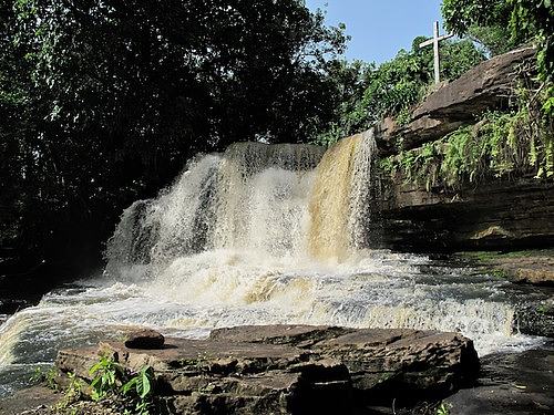
A gentler counterpart to Kintampo, about 7 km west of Kintampo at Yabraso. The water falls from the east over a series of cascades along the Oyoko River before flowing into the Black Volta at Dwire Kumbo. It is quieter and less developed than the main falls, which is precisely its appeal if you want the sound of water without the crowd.
Tip: Pair it with Kintampo Waterfalls in one day — they are close enough to visit back to back, and the contrast between the two is part of the pleasure.
-
Attraction
9.Kunsu Slave Cave
A cave and heritage site at Kunsu in the Kintampo North Municipality, linked by oral tradition to the transatlantic slave trade. Local accounts describe the caves as holding places from which captives were moved on towards markets such as Bono Manso. It is an undeveloped, sobering site rather than a polished attraction, and it asks for a quiet, respectful visit.
Tip: Go with a local guide who can relay the community's oral history, and allow time to simply sit with what you are seeing.
-
Attraction
10.Forikrom Boten Caves and Shrines
A range of giant rocks forming a shrine and cave complex near Forikrom, about 8 km off the Techiman–Nkoranza road. The largest, known as the Magic cave, is remembered as a refuge for Bono women and children in times of war. The scale of the boulders and the way they enclose sheltered spaces give the site a natural, almost architectural drama.
Tip: It sits off a minor road, so arrange transport in advance rather than expecting to flag something down at the turn-off.
-
Attraction
11.Nkoranza Palace
The Omanhene's palace and traditional seat of the paramount chief of the Nkoranza Traditional Area. It is a working seat of traditional authority rather than a museum, which is exactly why it is worth a look: it puts you in touch with the living chieftaincy system that still shapes land, custom and festival life across Bono East.
Tip: This is an active palace. Ask before photographing, dress modestly, and follow the guidance of whoever receives you.
-
Waterfall
12.Dandwa Waterfall
An undeveloped waterfall at Dandwa in the Nkoranza South Municipality, reached via the Nkoranza–Ejura highway. There are no facilities and no crowds — just a fall in its natural setting, which makes it a good choice for travellers who prefer their landscapes unmanicured and are happy to find their own way.
Tip: Because it is undeveloped, bring water, wear sturdy footwear and ask locally for the path; do not expect signage or a reception desk.


Plan your time
Suggested itinerary
Half a day: Kintampo's water and its centre
Start early at Kintampo Waterfalls, about 4 km north of town on the Kumasi–Tamale road. Take the first two stages, which are level and easy, then decide whether to tackle the roughly 173 steps down to the base of the third. Cross the canopy walkway for the view back over the gorge. On the way back into town, stop at the Centre of Ghana Monument near the old police station — a ten-minute pause, not a destination in itself. If you have energy left, push on 7 km west to Fuller Falls at Yabraso for a quieter, cascading finish.
Kintampo Waterfalls→Kintampo Canopy Walkway→Centre of Ghana Monument (Kintampo)→Fuller Falls
One day: the sacred and the monastic
Base yourself in or near Techiman and head north-east on the Techiman–Kintampo road. Begin at the Tanoboase Sacred Grove, walking the inselberg and its caves with a guide who can explain the Bono migration story and the Tano shrine. Continue a short way to Kristo Buase Monastery, where the Benedictine brothers welcome visitors and the rock formations and natural rock bridge are worth the stop. In the afternoon, visit Bono Manso, the old capital of Bonoman, and its memorial gardens — go slowly and ask what the community remembers. If time allows, end at the Tano River near Techiman Market, where you can see and feed the protected sacred fish, having first sought permission from the custodians.
Tano Boase Sacred Grove→Kristo Buase Monastery, Tanoboase→Nkoranza Palace
Two days: north to the caves and the grotto
Day one follows the sacred-and-monastic route above, finishing in Techiman. Day two heads north towards Kintampo: visit the Kunsu Slave Cave in the Kintampo North Municipality with a local guide, then continue to Kintampo for the waterfalls, canopy walkway and the Centre of Ghana monument, and finish at Fuller Falls. If you are travelling south instead, reverse the order and close with the Our Lady of Calvary Grotto at Asueyi, north of Techiman, especially around the August pilgrimage. Forikrom Boten Caves and Dandwa Waterfall both sit off minor roads and reward travellers with their own transport and a spare half-day.
Kunsu Slave Cave→Kintampo Waterfalls→Kintampo Canopy Walkway→Centre of Ghana Monument (Kintampo)→Fuller Falls→Our Lady of Calvary Grotto, Asueyi→Forikrom Boten Caves and Shrines→Dandwa Waterfall


Seasons and festivals
When to go
Bono East has a dry season from December to April and a wet season from roughly July to November, with average annual rainfall of 750 to 1050 mm. The hot Harmattan wind blows from the Sahara between December and early February, dry and dusty; temperatures can range from about 14°C at night to about 40°C by day, with the highest heat at the end of the dry season and the coolest nights in December and January. For the waterfalls, the Pumpum's flow peaks during the rains from May to October, while the dry season from November to March brings clearer water and easier access. Plan around whichever you value more: volume of water, or comfort on the trails.
- Apoo Festival, Techiman · Usually March, extending into April
- A purification festival for the people of Techiman and their environment, meant to rid the community of social evil. Apoo comes from the root word 'po', meaning to reject — in context, the rejection of evil, abominations, calamities, curses and worries. It is also a time when people give feedback to those who have offended them and hold traditional authorities to account, and it climaxes with the Nananom of the Techiman Traditional Council dancing to Apoo music. A highlight is Hyereko, the collection of white clay from the Aponkosu River, used to decorate the shrines of the traditional area.
- Kurubi Festival, Kintampo · November
- Celebrated by the people of Kintampo, mainly to unite people of Wangara descent in Ghana. Virgins dancing on stilts are a distinctive part of the festival.
- Nkyifie Festival, Prang · September and October
- Celebrated by the people of Prang in the Pru West District.
- Fokuo Festival, Nkoranza (Sessiman) · Annual
- A festival honouring the deity called Ntoa, also known as Seesiman Ntoa, who is remembered as playing a critical role in leading the historical wars of the people of Nkoranza.
Access
Getting there and around
Bono East is reached most easily along the Kumasi–Tamale highway, which runs through Kintampo and past the Kintampo Waterfalls turn-off about 4 km north of town. Kintampo is off that highway and is accessible by public transport, and the town serves as a major transit point for traders moving between the north and the south and the wider sub-Sahel. Techiman, the regional capital, is the other main hub, with the Techiman–Kintampo road linking the two and giving access to Tanoboase, Kristo Buase and Bono Manso along the way. The region borders Lake Volta to the east and the Ashanti Region to the south.
Once you are here, a vehicle of your own or a hired car with a driver makes the most sense: several of the best sites — Forikrom Boten Caves, Dandwa Waterfall, Kunsu Slave Cave — sit off minor roads with little or no public transport. For the waterfalls and the sacred grove, local guides are available at the sites or through the custodians, and it is worth arranging them in advance for the smaller, undeveloped places.
Good to know
Before you go
Bono East is a place of living tradition, and much of what you will visit is sacred rather than simply scenic. At the Tanoboase grove, the Tano River sites and the rock shrines, permission to visit must be secured from the custodians — ask first, and accept a no gracefully. Dress modestly at shrines, palaces and the monastery, and ask before photographing people, ceremonies or shrines. At the Kunsu Slave Cave and Bono Manso, remember that you are walking through a history of violence and loss; keep your voice low and your questions thoughtful.
The practical side matters too. The Harmattan between December and early February brings dust and dry heat, and daytime temperatures can reach around 40°C, so carry water, sun protection and a hat. Nights can drop to about 14°C, so a layer helps. The waterfalls are seasonal, and the rock surfaces are slippery — grip matters more than style. Several sites are undeveloped, with no facilities, so bring what you need and take everything out with you.


FAQ
Questions travellers ask about Bono East
Where is the Bono East Region?
It is in central Ghana, carved out of the former Brong Ahafo Region and established on 27 December 2018, with Techiman as its capital. It borders the Savannah Region to the north, the Bono Region to the west, Ashanti to the south and Lake Volta to the east.
What is Bono East best known for?
The three-drop Kintampo Waterfalls on the Pumpum River, the canopy walkway added at the same site, and the sacred groves and rock shrines around Tanoboase and Techiman. It is also the heartland of the old Bono state, whose capital was Bono Manso.
Can you swim at Kintampo Waterfalls?
Swimming or bathing is permitted only at the base of the third stage. It is not allowed at the first and second stages, and the rock surfaces throughout are slippery.
When is the best time to see the waterfalls?
The Pumpum's flow peaks during the rainy season from May to October, when the falls are at their fullest. The dry season from November to March brings clearer water and easier access on the trails.
What is the Apoo Festival?
A purification festival celebrated in Techiman, usually in March and extending into April, to rid the community of social evil. The name comes from 'po', meaning to reject, and it is also a time for people to air grievances and hold traditional authorities to account.
Do you need permission to visit the sacred sites?
Yes. The Tano River sites and the shrines at Tanoboase are accessible to visitors, but permission to visit them must be secured from their custodians.
How do you get around Bono East?
The Kumasi–Tamale highway runs through Kintampo, which is accessible by public transport, and Techiman is the other main hub. For the smaller sites off minor roads, such as Forikrom Boten Caves and Dandwa Waterfall, your own vehicle or a hired car with a driver is the practical option.
Sources for this guide (10)
- Kintampo Waterfalls — Visit Ghana
- Kintampo waterfalls — Wikipedia
- Bono East Region — Wikipedia
- Tanoboase Sacred Grove — Nkwantananso Cultural Centre, University of Michigan
- Kristo Buase Monastery at Tanoboase — Nkwantananso Cultural Centre
- "Grotto" — Our Lady of Calvary Sanctuary — Nkwantananso Cultural Centre
- Manso — Nkwantananso Cultural Centre
- Tano River — Nkwantananso Cultural Centre
- Apoo Festival — Visit Ghana
- Kintampo! Let's go to the Centre of Ghana — Graphic Online
Written September 29, 2026 from these sources and reviewed by the VisitGhana.app team. Confirm practical details locally before travelling.