
A coast of forts, built for gold and used for slaves
The Western Region holds the densest run of historic fortifications in Ghana. The Ghana Museums and Monuments Board lists eight here as National Monuments: Fort Apollonia at Beyin, Fort St. Anthony at Axim, Fort Gross Friedrichsburg at Princestown, Fort Dorothea at Akwidaa, Fort Metal Cross at Dixcove, Fort Batenstein at Butre, Fort Orange at Sekondi and Fort San Sebastian at Shama. Several are part of the UNESCO World Heritage property 'Forts and Castles, Volta, Greater Accra, Central and Western Regions', whose fortified trading posts were founded between 1482 and 1786 and stretch roughly 500 km along the coast from Keta to Beyin.
The forts were commercial ventures before they were anything else. The Portuguese began Fort St. Anthony at Axim in 1515 to command the gold-rich Ankobra and Tano valleys; the Dutch built Fort Batenstein above Butre in 1656 for the same promise of inland gold; the British started Fort Metal Cross at Dixcove in 1692 partly to win back English traders who had drifted to the Brandenburgers' fort at Princestown. Fort Gross Friedrichsburg, built between 1683 and 1684, is the only fort in Ghana with Germanic origins, and its story is bound up with the Ahanta chief John Conny, who took it over and held it for seven years before the Dutch finally dislodged him in 1724.
It is impossible to tell this story without naming what the forts became. As the gold trade gave way, they served the developing slave trade, and UNESCO describes them as a collective monument both to the evils of that trade and to centuries of pre-colonial Afro-European commerce. Fort Metal Cross became a slave prison; Fort San Sebastian, built by the Portuguese from 1520 to 1526 and later expanded by the Dutch, saw some trade in gold and slaves before its commercial life faded. Walk these ramparts slowly. The views are beautiful and the history is not.

People of the western coast: Ahanta, Nzema and Wassa
The Western Region is an Akan region, home principally to the Wassa, Ahanta and Nzema peoples, with Fante widely spoken alongside the local dialects. Busua, for instance, is an Ahanta fishing village where the Ahanta language is spoken, and its boats are known for blue marlin and tuna. The Nzema country around Beyin and Axim gives its name to the Museum of Nzema Culture and History, housed since 2010 inside the restored Fort Apollonia at Beyin — a good place to understand the coastal cultures before or after a canoe trip.
Life here is still shaped by the water and the forest. Nzulezo's residents fish, farm nearby land and host visitors; the village keeps its own rules, including a sacred Thursday on which strenuous work is not done. In Butre, a community-run Town Tourism Development Committee arranges guided walks to Fort Batenstein and the surrounding area, and the village information booth connects visitors with local guides. These community arrangements are the norm rather than the exception on this coast, and using them keeps tourism money close to the villages that host it.

Rainforest, wetlands and the southernmost tip
Inland from the coast, the Ankasa Conservation Area covers 509 km² and combines Nini-Suhien National Park with the Ankasa Resource Reserve. The Forestry Commission calls it a remnant of the rainforest that once stretched across West Africa, and it is the only wildlife protected area in Ghana lying in the wet evergreen tropical high rainforest belt. It shelters forest elephant, bongo, leopard and yellow-backed duiker, nine primate species including the Roloway Diana monkey, and nearly 200 bird species; the forest also holds over 800 vascular plant species and more than 600 butterfly species. Birdwatching, hiking and rock climbing are all possible here.
At the coast's far western edge, the Amansuri wetland near Beyin is a Ramsar site and the largest inland swamp forest in Ghana, and it is the route to Nzulezo. The canoe journey passes marshes, swamp forest and open pools rich with crocodiles, egrets, herons and kingfishers, in an area designated an Important Bird Area. Further east, Cape Three Points is Ghana's southernmost tip, where a 1925 solar-powered lighthouse looks out over the country's only coastal rainforest reserve, rolling hills and the Atlantic. The drive there passes oil palm and rubber plantations, and the surrounding waters are used by migrating whales and dolphins.

What to do
Things to do in Western
-
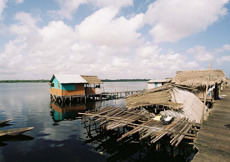
1.Canoe to Nzulezo stilt village
Ghana's only stilt village, reached by dugout canoe from the Beyin visitor centre through the Amansuri wetland and across Lake Tadane. The 45-minute to one-hour paddle passes marshes, swamp forest and open pools full of birds and crocodiles before the village appears on the water. Nzulezo means 'surface of the water' in Nzema, and its people live, school and worship above the lake.
Tip: Arrange the trip at the Beyin visitor centre; the village keeps Thursday sacred, so plan around it.
-
2.Fort Apollonia and the Museum of Nzema Culture and History
The westernmost of Ghana's coastal forts, at Beyin, began as an English trading post granted by the Nzema chief Amenihyia and was built from 1768. Abandoned after the slave trade was abolished, later held by the Dutch and bombarded by the British in 1873, it was rehabilitated in the 1960s and now houses the Museum of Nzema Culture and History, opened in 2010. It sits right beside the beach and the wetland.
Tip: Pair it with the Nzulezo canoe trip, since both start from Beyin.
-
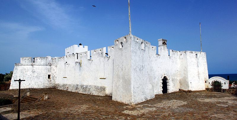
3.Fort Metal Cross, Dixcove
Begun by the British in 1692 on a promontory above the fishing village of Dixcove, this fort was built to tap inland gold and to win back English traders from the Brandenburgers' fort nearby. It later became a slave prison, passed to the Dutch in 1868 and back to the British in 1872. It is a UNESCO-listed protected monument, and the working harbour below is a fine place to watch canoes come in.
Tip: Combine it with the short walk west from Busua, which takes about 25 minutes.
-
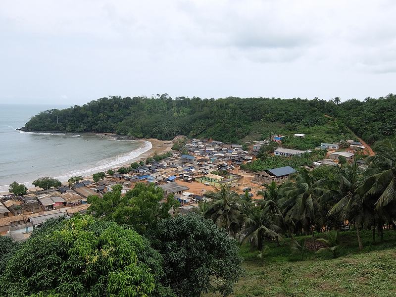
4.Fort Batenstein and the Butre hills
The Dutch built this small trading fort in 1656 on the high hill behind Butre, drawn by the promise of gold inland. Its guns once shook the building when fired in salute, and the view over the Atlantic coastline from its bastions is remarkable. Now preserved as a ruin and consolidated in 2010–2011, it is reached on foot from the village, where a community tourism committee runs guided walks.
Tip: Ask at the Butre information booth for a local guide; the climb is steep but short.
-
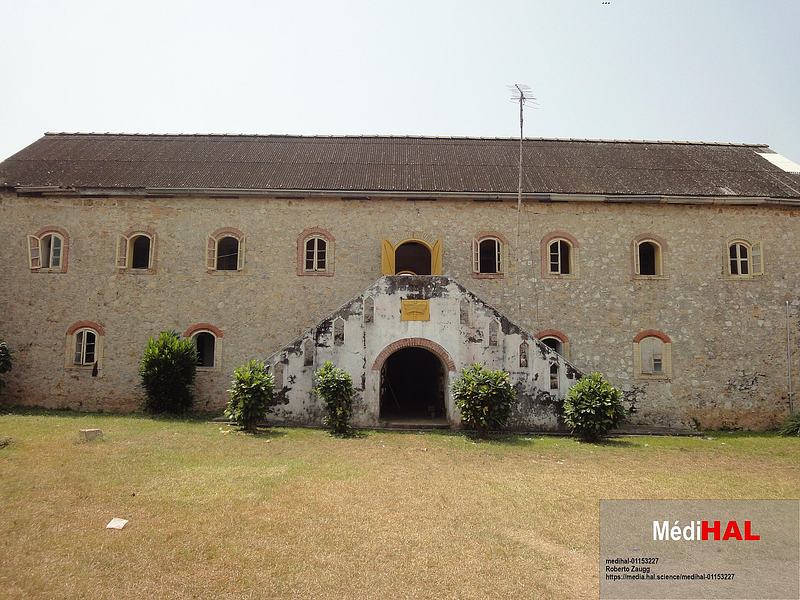
5.Fort Gross Friedrichsburg, Princestown
Ghana's only German-built fort, raised on Manfro Hill at Princestown between 1683 and 1684 as the headquarters of the Brandenburg Africa Company. It became a hub for smugglers and was later seized by the Ahanta chief John Conny, who held it for seven years and resisted Dutch attempts to retake it. It now serves as a rest house and is a partially restored attraction.
Tip: The John Conny story is the reason to come; read up before you climb the hill.
-
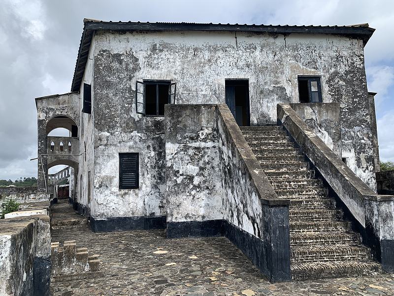
6.Fort St. Anthony, Axim
Begun by the Portuguese in 1515 on a rocky promontory near the Ankobra River, this was the second Portuguese fort on the Gold Coast after Elmina. Its three-metre rock-cut trench helped it withstand attack for over four years, and it later became a Dutch stronghold that amassed great quantities of gold. Its 17th- and 18th-century panelling is an archaeological highlight.
Tip: Check locally before travelling, as access to the fort has changed at times.
-
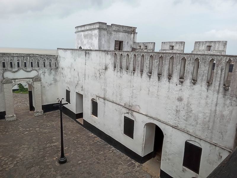
7.Fort San Sebastian, Shama
Ghana's third-oldest fortification, built by the Portuguese between 1520 and 1526 and substantially expanded by the Dutch from 1640 to 1643. Described as a small-scale copy of Elmina's St. George's Castle, it was ceded to the British in 1872 and rehabilitated in 1957. It is a National Monument within the UNESCO-listed forts and castles of Ghana.
Tip: It is close to Takoradi, making it an easy stop on the way in or out of the city.
-
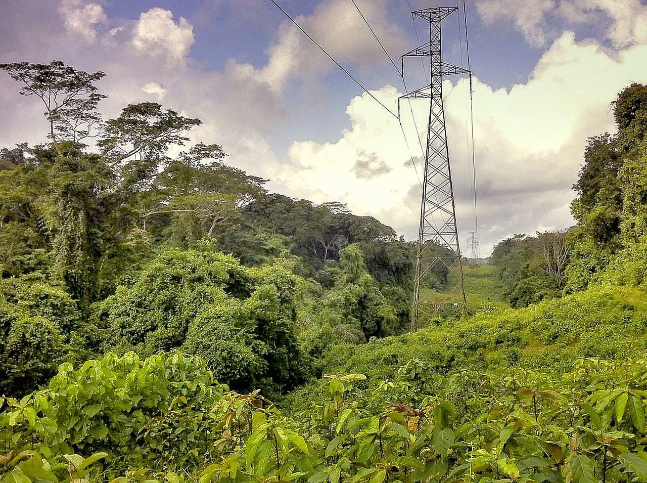
Photo: Francesco Veronesi · CC BY-SA 2.0 · Source 8.Ankasa Conservation Area
A 509 km² protected area combining Nini-Suhien National Park and the Ankasa Resource Reserve, and the only wildlife reserve in Ghana's wet evergreen high rainforest belt. Expect towering forest, rivers and waterfalls, forest elephant, bongo, leopard, nine primate species and nearly 200 birds. Birdwatching, hiking and rock climbing are all on offer in what the Forestry Commission calls a forest that time forgot.
Tip: Bring sturdy footwear and rain protection; the forest is wet year-round.
-
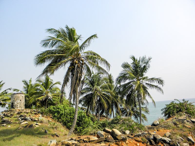
9.Cape Three Points and its lighthouse
Ghana's southernmost tip, where a 1925 solar-powered lighthouse gives a panoramic view over the country's only coastal rainforest reserve, rolling hills and the Atlantic. The drive there passes oil palm and rubber plantations, and the waters offshore are used by migrating whales and dolphins. A caretaker is on hand to show visitors around.
Tip: Whale sightings are most likely between August and February, dolphins between July and November.
-
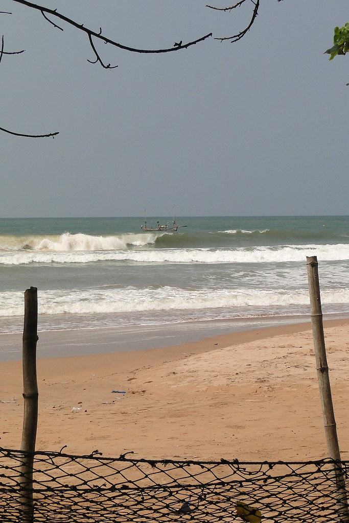
10.Busua Beach and its surf
A long sandy beach at an Ahanta fishing village about 30 km west of Sekondi-Takoradi, with a coastline free of dangerous currents and a reputation as a surf destination with schools on the sand. Busua has been a seaside retreat since before the 1960s, and its boats still land blue marlin and tuna. It is the natural base for exploring Dixcove and Butre on foot.
Tip: Walk west to Dixcove in about 25 minutes, or east to Butre for Fort Batenstein.
-
Attraction
11.Beyin sea turtle conservation
The beach beside the Beyin visitor centre is the site of a sea turtle conservation project run with the Ghana Wildlife Society, protecting three endangered species that nest there. Evening tours are offered to watch turtles laying eggs and hatchlings making their way to the sea. It is a rare chance to see conservation work up close on this coast.
Tip: Turtle walks run from October through August; go with the project's guides and keep lights and noise low.
-
Attraction
12.Butre River canoe and mangrove trip
A guided dugout-canoe trip upstream from Butre village, run as a lodge and community activity, through the mangroves and quiet water of the Butre River. It is a gentle, close-up way to see the estuary and lagoon that sit between the village and the sea, and it pairs naturally with the walk up to Fort Batenstein.
Tip: Book through the Butre community tourism booth or your lodge so a local navigator takes you.


Plan your time
Suggested itinerary
Half a day: forts and surf around Busua
Base yourself at Busua and use the morning for the coast's history and beach. Walk west along the sand to Dixcove (about 25 minutes) to see Fort Metal Cross above the working harbour, then return and walk east to Butre for the steep climb to Fort Batenstein and its view over the Atlantic. Finish with an afternoon on Busua Beach, watching the fishing canoes land or taking a surf lesson.
Fort Metal Cross→Fort Batenstein→Busua Beach
One day: Beyin, Nzulezo and the turtles
Drive west to Beyin and start at the visitor centre, where you arrange the dugout canoe trip to Nzulezo stilt village through the Amansuri wetland and across Lake Tadane. Back on the coast, visit Fort Apollonia and the Museum of Nzema Culture and History beside the beach. If you are travelling between October and August, stay for an evening sea turtle tour on the beach next to the visitor centre.
Nzulezo Stilt Village→Beyin Sea Turtle Conservation (evening turtle tours)
Two days: rainforest, cape and the far west
Day one heads inland to the Ankasa Conservation Area for forest trails, waterfalls and birdwatching, then continues to the coast. Day two takes in Cape Three Points and its 1925 lighthouse for the panorama over Ghana's only coastal rainforest reserve, before looping back through Axim to see Fort St. Anthony and, on the way home, Fort San Sebastian at Shama. Add a stop at Fort Gross Friedrichsburg at Princestown if time allows.
Ankasa Rain Forest→Cape Three Points→Fort St. Antony→Fort San Sebastian, Shama→Fort Gross-Friedrichsburg

Seasons and festivals
When to go
The Western Region is warm and humid year-round, and the wetter months change what you can do rather than whether you can travel. On the Nzulezo canoe route, more birds and monkeys are seen during the rainy season from mid-May through August, when you can paddle the whole way; in the dry season you walk the first kilometre before boarding. Guided sea turtle walks at Beyin run from October through August. At Cape Three Points, whales are most likely between August and February and dolphins between July and November. The region's harvest and cultural festivals, including Kundum among the Ahanta and Nzema, are tied to local calendars and vary between towns, so check dates locally before planning around one.
- Kundum · Varies by town and traditional area
- A harvest and cultural festival associated with the Ahanta and Nzema peoples of the Western Region. Customs and dates differ between communities, so confirm locally rather than assuming a single regional date.
Access
Getting there and around
Sekondi-Takoradi is the region's capital and transport hub. From Accra, the main highway runs west through Cape Coast to Takoradi, and Takoradi Airport (TKD) handles domestic flights from Accra. Once in the region, most travellers move by road: the coast road links Shama, Busua, Dixcove, Butre, Axim and on to Beyin, while the far west toward Elubo and the Ivorian border is reached by the same coastal corridor. Nzulezo is reached from the visitor centre at Beyin, about 90 km west of Takoradi, by dugout canoe; the drive from Accra to the far west is long, so many visitors break the journey. Local taxis, tro-tros and arranged drivers cover the smaller towns, and community tourism booths in places such as Butre can connect you with guides.
Good to know
Before you go
Treat the forts as places of memory as well as monuments. Several served the slave trade, and a quiet, unhurried visit is more appropriate than a hurried photo stop. Many sites are managed by the Ghana Museums and Monuments Board and keep regular daytime opening hours, but access can change, so confirm locally before making a special journey. At Nzulezo, respect the village's rules, including its sacred Thursday, and remember that people live here: ask before photographing individuals. Use community guides and tourism booths where they exist, as they keep income in the villages. The climate is hot and humid, so carry water, sun protection and rain gear, and take anti-malarial precautions. Bring cash for small purchases and community fees, and dress modestly away from the beach.

FAQ
Questions travellers ask about Western
Where is the Western Region of Ghana?
It lies in southern Ghana, stretching from the border with Côte d'Ivoire in the west to the Central Region in the east, with Sekondi-Takoradi as its capital. It includes Ghana's southernmost point, Cape Three Points.
How do I get to Nzulezo stilt village?
You travel by dugout canoe from the visitor centre at Beyin, about 90 km west of Takoradi. The trip takes roughly 45 minutes to an hour through the Amansuri wetland and across Lake Tadane.
Which forts can I visit in the Western Region?
Eight are listed as National Monuments: Fort Apollonia at Beyin, Fort St. Anthony at Axim, Fort Gross Friedrichsburg at Princestown, Fort Dorothea at Akwidaa, Fort Metal Cross at Dixcove, Fort Batenstein at Butre, Fort Orange at Sekondi and Fort San Sebastian at Shama.
When can I see sea turtles at Beyin?
Guided evening turtle walks run from October through August on the beach beside the Beyin visitor centre, where a conservation project protects three endangered nesting species.
Is Busua good for surfing?
Yes. Busua is a beach resort and fishing village with a long sandy beach and a coastline free of dangerous currents, and surf schools operate on the sand.
What wildlife can I see in the Ankasa Conservation Area?
The forest holds forest elephant, bongo, leopard, yellow-backed duiker, nine primate species including the Roloway Diana monkey, and nearly 200 bird species, along with over 800 plant species and more than 600 butterflies.
What is special about Cape Three Points?
It is Ghana's southernmost tip, marked by a 1925 solar-powered lighthouse with views over the country's only coastal rainforest reserve and the Atlantic. Whales and dolphins use the surrounding waters seasonally.
Sources for this guide (14)
- Forts and Castles – Ghana Museums and Monuments Board
- Fort Apollonia, Beyin (1768) – GMMB
- Fort Metal Cross, Dixcove (1692) – GMMB
- Fort Batenstein, Butre (1656) – GMMB
- Fort Gross Frederiksburg, Princestown (1683) – GMMB
- Fort St. Anthony (San Antonio), Axim (1515) – GMMB
- Fort San Sebastian, Shama (1526) – GMMB
- Forts and Castles, Volta, Greater Accra, Central and Western Regions – UNESCO World Heritage Centre
- Ankasa Conservation Area – Forestry Commission Ghana
- Ankasa Conservation Area – Wikipedia
- Western Region (Ghana) – Wikipedia
- Busua – Wikipedia
- Nzulezu stilt village – Visit Ghana
- Cape Three Point – Visit Ghana
Written September 29, 2026 from these sources and reviewed by the VisitGhana.app team. Confirm practical details locally before travelling.


