
A region shaped by water and a dam
The Oti Region was formed from the former Volta Region and inaugurated in 2019, with Dambai named as its capital on the eastern bank of the Oti River, a tributary of Lake Volta. The region borders Togo to the east, the Northern Region to the north, and the Volta Region to the south and west, and comprises eight districts including Nkwanta South, Krachi East, Biakoye and Jasikan. Much of what visitors see here was remade within living memory. When the Akosombo Dam closed and the Volta backed up, a vast area was flooded and communities were moved to higher ground; Kete Krachi, once an important trading and spiritual centre on the river, was resettled, and the old town now lies beneath the lake. The fishermen working these waters are working over drowned farmland, and the dead trees standing in the shallows are the remains of forest that was there before. Understanding that history changes how the lake looks.

The Akyode and the hanging village
The Akyode, also called Kyode or Gikyode, are a Guan-speaking people who live in the northern Volta basin around Kyabobo Mountain. They are made up of communities including Shiare, Pawa, Keri, Gekorong and Kyilinga, and their paramount seat is at Shiare, where the chief is known as the Shiare Wura or Osulewura. Shiare itself is a settlement of roughly nine centuries, its houses built of rock and clay on terraces along the contour of the Breast Mountains, so that the village appears to cling to the hillside — hence its name, the Hanging Village. Oral history traces the people's migration from Ejisu in the Ashanti Region. Residents are subsistence farmers growing cassava, yams and vegetables, and they also produce honey; the village's waterfall is its only source of water, channelled down through a stream. The Akyode are not the region's only people — Dambai alone is home to Nchumuru, Ewe, Konkomba, Hausa, Kotokoli and Basari communities — and that mix is part of the region's character.

Mountains, forest and falling water
The Oti Region's landscape runs from dry semi-deciduous forest into tree savannah, with drought-resistant baobabs and acacias, a dry season from December to April and rains from July to November. Kyabobo National Park sits on the Togo border near Nkwanta, protecting a transition zone between rainforest and savannah that shelters buffalo, kob, warthog, bushbuck, duikers and baboon, alongside hundreds of butterfly and bird species. Ghana's second-highest mountain, Mount Dzebobo, rises inside the park and offers views toward Lake Volta, while two adjacent hills form the Breast Mountains, whose summit viewpoint is reached by trail. Water is the other constant: the multi-tiered Laboum waterfall inside the park, the perennial Bowiri Abohire falls in Biakoye District, which drops about fifty metres into a rocky pool fed by two streams, and the cascades at Bowiri Aboabo. The region's climate is hot and, at night in the Harmattan, surprisingly cool, with temperatures that can fall toward 14°C and rise to 40°C in the day.

What to do
Things to do in Oti
-
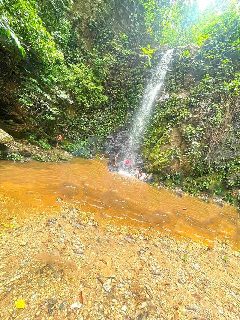
1.Hike Kyabobo National Park
The region's defining experience: a mountainous park on the Togo border protecting a transition between forest and savannah, with buffalo, kob, bushbuck, duikers and baboon, and a survey listing at least 500 butterfly species and 235 birds. Trails range from short walks to challenging multiple-day hikes, and there are game-viewing hides, shrines and sacred groves. The park is about 400 km from Accra, and plans are afoot to link it with the contiguous Fazao-Malfacassa National Park in Togo.
Tip: The waterfall and the Koue River are at their most dramatic after the rains, from August to December.
-
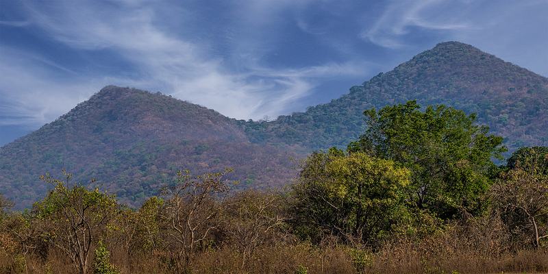
2.Stand on the Breast Mountains
Two adjacent hills inside Kyabobo whose silhouette resembles a woman's breasts, with a summit viewpoint on the left hill known as the Nipple. The climb is one of the park's signature walks, and on a clear day the view reaches all the way to the Volta. The park's own guidance rates the outing at around three hours and moderate difficulty, and it can also be done by mountain bike from the headquarters.
Tip: Start early for the clearest air and the best chance of a long view.
-
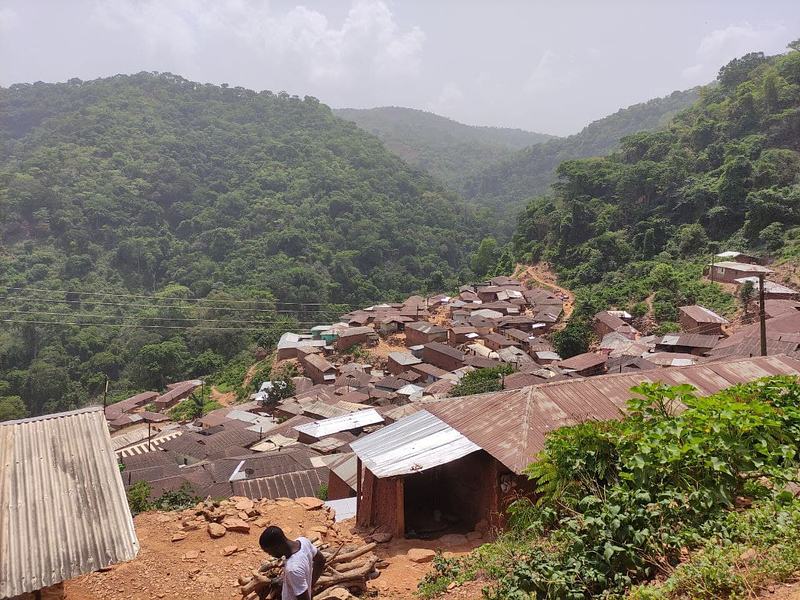
3.Visit Shiare, the Hanging Village
A roughly nine-hundred-year-old Akyode settlement in the Breast Mountains, its rock-and-clay houses built on terraces along the hillside so that the village seems to hang from the slope. Shiare is the paramount seat of the Kyode people and the ancestral home of the Akyode, and it remains a working farming community rather than a staged attraction. It lies about a thirty-minute drive from Nkwanta, though the road can be rough.
Tip: Arrange your visit with community guides and the local chief, and treat homes and shrines as living places, not exhibits.
-
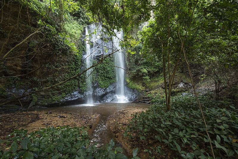
4.Walk to Shiare Waterfalls
The waterfall below Shiare is the village's only source of water, channelled down the mountain through a stream, and it does not dry up even in long spells without rain. Reaching it means a steep foot trek of roughly thirty to forty minutes from the village, through the scenery that makes the Breast Mountains memorable. For residents this is everyday infrastructure; for visitors it is one of the region's most rewarding short walks.
Tip: Wear shoes with grip — the descent is steep and can be slippery after rain.
-
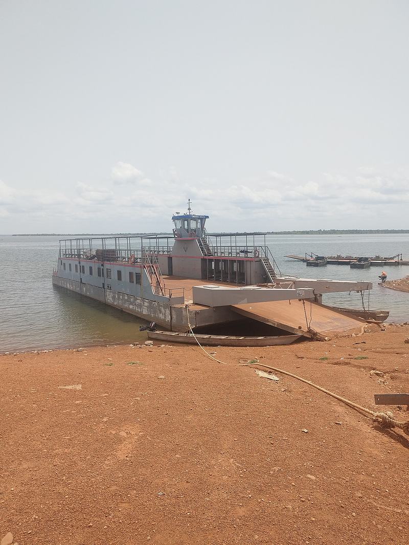
5.Cross the Oti River at Dambai
The ferry at Dambai carries passengers and vehicles across the Oti River, linking the town with the opposite bank and with Kwadjokrom, and it is genuinely the most enjoyable way to arrive in the region. This is working transport rather than an excursion: vehicles, traders, sacks of yam, goats and motorbikes all go on together. The crossing is also the best introduction to the drowned landscape of Lake Volta and the communities that live from it.
Tip: Go early for the best light and the shortest queues, and ask locally the day before — services run to demand, weather and water level, not to a promise.
-
Waterfall
6.Laboum Waterfall, Kyabobo
A multi-tiered waterfall on the Laboum River inside Kyabobo National Park, reached only on foot along the park's hiking trails. The VisitGhana guide describes a fall of about sixty metres with a pool at its foot for a dip, and a nearby game-viewing hide from which to watch birds and small mammals. The park rates the outing at around five hours and a higher difficulty, so it suits those ready for a proper day's walk.
Tip: Take water and allow the full day; the trail is rough and the return is as long as the approach.
-
Waterfall
7.Bowiri Abohire Waterfall
A perennial waterfall in Biakoye District, reached by road via Kwamekrom and then about a twenty-five-minute walk along a forest path that opens into pristine jungle. The water falls roughly fifty metres into a rocky pool, fed by two streams, the Abohire and the Kekremutu, and the surrounding canopy keeps the air cool. The district assembly has made the falls the focus of its annual corporate day, and it is one of the region's most accessible natural sites.
Tip: Combine it with the nearby Bowiri Abohire cave, which the Ghana Tourism Authority has assessed alongside the falls.
-
Waterfall
8.Bowiri Aboabo Water Cascades
A set of water cascades at Bowiri Aboabo in Biakoye District, listed by the district assembly among its natural tourist sites and known locally, after a district initiative, as the Bowiri Aboabo Quadruplet Waterfalls. Like the Abohire falls nearby, it sits in the greener, southern half of the Oti Region, where cocoa and food-crop country gives way to forest. It remains a community site rather than a developed attraction.
Tip: Ask at the Biakoye District Assembly or in Kwamekrom for a local guide before setting out.
-
Attraction
9.Dambai Market and the lakeside market
Dambai's market is the trading hub for Krachi East Municipality and beyond, drawing buyers and sellers from across the district and from Togo. The town's lakeside market trades mainly on Mondays and Tuesdays, with produce brought in from the Oti River area, and the two together give a good sense of how the region's economy actually moves. Come for the yams, the river fish and the sheer volume of trade.
Tip: Time your visit to a Monday or Tuesday, when the market is at its fullest.
-
Attraction
10.Nkwanta Town Market
The main market of Nkwanta, the district capital of Nkwanta South, and a major Monday market known especially for yam trading. It is the natural place to stock up before or after a Kyabobo hike, and the surrounding communities are famous for their yam festivals, held each year around August and September. The town is also the practical base for the park, with chop bars, restaurants and hotels.
Tip: Nkwanta is the last sizeable town before the park — sort out supplies, cash and fuel here.
-
Waterfall
11.Kyakyale Waterfalls, Shiare
A forest waterfall near Shiare in Nkwanta South Municipal District, also called Nyingilin Kyakyale Waterfalls. It sits in the same hill country as the Hanging Village and the Breast Mountains, so it pairs naturally with a visit to Shiare. Like many of the region's falls it is a community-documented site rather than a developed one, best reached with a local guide who knows the paths.
Tip: Ask in Shiare or Nkwanta for a guide who can combine the falls with the village walk.
-
Attraction
12.Kyabobo headquarters and entrance
The administrative base and arrival point for Kyabobo National Park, about five kilometres off the Ho–Temale Road at Nkwanta, where guided hikes and mountain-bike rental are arranged. The headquarters is landscaped and is the place to plan a visit, hire a guide and pick up the park's trail options, including the ride around Breast Mountain with a stop at Keri village. A campsite with showers and flush toilets sits adjacent.
Tip: Sort out your guide and route here before heading into the hills — the park is open from 6am to 6pm daily.


Plan your time
Suggested itinerary
Half a day: Dambai and the river
Start early at the Dambai ferry site and cross the Oti River with the traders and their loads — the morning light on the water is the best of the day. Back on the eastern bank, walk the lakeside market and the main Dambai market, which trade hardest on Mondays and Tuesdays, then take a slow loop along the waterfront where canoes and the working crossing double as the town's best scenery. Finish at Lapas Park, the open ground where Dambai gathers for community and sporting events.
Dambai Volta ferry crossing→Dambai Lake Side Market→Dambai Market→Lake Volta Boat Ride Experience→Lapas Park
One day: Kyabobo and the Breast Mountains
Leave Nkwanta early for the Kyabobo National Park headquarters and entrance, five kilometres off the Ho–Temale Road, and arrange a guide and your route. Walk up to the Breast Mountains viewpoint for the long view toward the Volta, then, if you have the legs and the hours, continue to the multi-tiered Laboum waterfall and its pool. Birdwatchers should keep an eye out for the park's forest and savannah species. Return to Nkwanta in the evening for food and a bed.
Kyabobo National Park Headquarters and Entrance→Breast Mountain→Laboum Waterfall→Kyabobo National Park→Nkwanta Town Market
Two days: Shiare, the hills and the southern falls
Day one: drive from Nkwanta to Shiare, the Hanging Village, and spend the morning among its terraced rock-and-clay houses with a community guide, then make the steep thirty-to-forty-minute trek down to Shiare Waterfalls. Add the Kyakyale falls nearby if time allows, and stay overnight in the Nkwanta area. Day two: head south into Biakoye District for the perennial Bowiri Abohire waterfall, a twenty-five-minute forest walk from the roadside, and the Bowiri Aboabo cascades, finishing with the drive back toward Dambai and the river.
Shiare Hanging Village→Shiare Waterfalls→Kyakyale Waterfalls→Bowiri Abohire Waterfall→Bowiri Aboabo Water Cascades


Seasons and festivals
When to go
The Oti Region has a dry season from December to April and a wet season from July to November, with average annual rainfall of between 750 mm and 1050 mm. The dry months are the practical window: roads are more passable, the lake is calmer and crossings are more predictable. The Harmattan blows from the Sahara between December and early February, bringing dusty air and cool nights that can drop toward 14°C, while daytime temperatures can still reach 40°C. The rains from July to November turn the country green and fill the rivers and waterfalls, but unpaved roads deteriorate quickly and rough water can interrupt ferry services. For the park's waterfall and the Koue River, the VisitGhana guide recommends the period after the rains, from August to December. The villages of Shiare, Koue and Kylinga and their shrines can be visited at any time with community guides, after arrangements are made with the local chief.
- Kete Krachi Festival · Annual; dates move, so confirm locally
- One of the two key festivals celebrated in the Oti Region, held at Kete Krachi, the older town west of Dambai. Dates shift from year to year, so check before planning travel around it.
- Nanaba Festival · Annual; dates move, so confirm locally
- The other principal festival of the Oti Region, alongside the Kete Krachi Festival. As with Kete Krachi, the dates are not fixed, so confirm the current year's timing locally.
- Yam festivals, Nkwanta area · Around August to September
- Nkwanta and the communities around Kyabobo National Park are known for their yam festivals, held every year around August and September — a good reason to time a visit to the park with local celebration.
Access
Getting there and around
Dambai, the regional capital, sits on the eastern bank of the Oti River, a tributary of Lake Volta, and is the main gateway. From Accra and the south, the journey is roughly 350 km, most easily via Ho and the Volta Region road north, or via Hohoe and Jasikan; budget the better part of a day, as the last stretches are slower than the map suggests. From the north, Dambai connects toward Bimbila and the Northern Region. Kyabobo National Park is about 400 km from Accra; from the main Ho–Temale Road at Nkwanta, turn at the Kyabobo National Park sign and continue five kilometres to the headquarters. Trotros run from Accra, Hohoe and Tamale (changing at Bimbila), and local taxis may be available for the last stretch from the main road to the visitor centre. Ferries cross between Dambai and Kete Krachi and the far bank, including to Kwadjokrom; these are working crossings that run to demand, weather, water level and mechanical reality rather than to a published timetable, so ask locally the day before and allow plenty of slack. Locally, shared taxis and motorbikes cover short distances, and a hired vehicle is best for anything further; the road between Dambai and Kete Krachi is the one you are most likely to need, and it is not quick.
Good to know
Before you go
Bring cash: draw before you come, as you should not rely on finding a working ATM in Dambai, and fill up with fuel in the larger towns, where supply can be intermittent. Malaria is a year-round risk near the lake, and the standing water makes it worse, so take precautions seriously. Lake Volta carries bilharzia — do not swim, however inviting the water looks. English works in the towns, but this is a region of many languages, and a local contact opens doors that nothing else will. Check current security advice for the Nkwanta area before travelling, and ask locally on arrival; parts of the region have experienced communal and chieftaincy-related conflict, with curfews imposed at various times. Around Shiare and other Akyode communities, arrange visits through community guides and the local chief, dress modestly, and ask before photographing people, shrines or sacred sites. Accommodation is limited and simple, so plan where you will sleep before you set out.


FAQ
Questions travellers ask about Oti
Where is the Oti Region and what is its capital?
The Oti Region is in northern Ghana, formed from the former Volta Region and inaugurated in 2019. Its capital is Dambai, on the eastern bank of the Oti River, a tributary of Lake Volta, and it borders Togo to the east, the Northern Region to the north and the Volta Region to the south and west.
What is there to do in Kyabobo National Park?
The park offers hiking and multiple-day treks, mountain biking, game-viewing hides, shrines and sacred groves, plus the climb to the Breast Mountains viewpoint and the multi-tiered Laboum waterfall. Its wildlife includes buffalo, kob, warthog, bushbuck, duikers and baboon, with hundreds of butterfly and bird species recorded.
What is Shiare, the Hanging Village?
Shiare is a roughly nine-hundred-year-old Akyode settlement in the Breast Mountains of Nkwanta South Municipal District, where houses of rock and clay are built on terraces along the hillside so the village appears to hang from the slope. It is the paramount seat of the Kyode people and remains a working farming community.
When is the best time to visit the Oti Region?
The dry season from December to April is the most practical window, with more passable roads and calmer water. The rains from July to November make the waterfalls and rivers most dramatic but can slow travel and interrupt ferry crossings. The Harmattan brings dusty air and cool nights from December into early February.
How do I cross the Oti River at Dambai?
A ferry carries passengers and vehicles across the Oti River, linking Dambai with the opposite bank and with Kwadjokrom. It is working transport rather than a scheduled excursion, so ask locally the day before, go early, and allow far more time than you expect.
Which festivals are celebrated in the Oti Region?
The two key festivals are the Kete Krachi Festival and the Nanaba Festival, both of which move from year to year, so confirm dates locally. Nkwanta and the communities around Kyabobo National Park also hold yam festivals each year around August and September.
Is it safe to swim in Lake Volta or the Oti River?
No. Lake Volta carries bilharzia, and the standing water near the lake increases the risk, so do not swim however inviting the water looks. Malaria is also a year-round risk in the lakeside areas, so take precautions seriously.
Sources for this guide (11)
- Oti Region – Visit Ghana
- Kyabobo National Park – Visit Ghana
- Ghana Wildlife Division: National Wildlife Reserves
- Kyabobo National Park – Herit360
- Shiare – Wikipedia
- Kyode people – Wikipedia
- Dambai – Wikipedia
- Dambai — Oti Region Capital – Ghana-Net
- Tourism in Biakoye – Biakoye District Assembly
- Biakoye District Corporate Day Celebrated – Biakoye District Assembly
- Shiare waterfalls; the hidden treasure of Nkwanta – Modern Ghana
Written September 29, 2026 from these sources and reviewed by the VisitGhana.app team. Confirm practical details locally before travelling.