

A town at the meeting of peoples
Nkwanta sits where the forest thins into savannah, and its history is a history of movement. The Akyode, also called Kyode, are recorded as the first settlers of Nkwanta and its surroundings, a Guan-speaking people who live around Kyabobo Mountain and whose oral tradition traces their migration into the Volta valley from the Mossi region of what is now Burkina Faso. Their paramount seat is at Shiare, in the Breast Mountains, and their chiefs carry the title wura.
Others came later and stayed: the municipality's own profile lists Ntrubo, Adele, Atwode and Konkomba among its major groups, with Ewe, Akan, Kotokoli and Basare communities alongside them. That mix is the town's character and, at times, its difficulty. Disputes over land and chieftaincy between the Adele, Akyode and Challa communities have flared repeatedly, most seriously since late 2021, and the Oti Regional Security Council has kept a ban on festivals inside Nkwanta township since November 2023. In March 2026 the National Peace Council brought the three traditional councils together for a dialogue and a signed commitment to non-violent resolution. Travellers should treat this as a live situation, not background colour, and follow local advice.


The hanging village and the yam festival
North of town, the Breast Mountains rise out of the plain, and on their slopes sits Shiare, known as the Hanging Village. Its houses are built of rock and clay on terraces cut along the contour of the mountain, so that from below the settlement appears to cling to the hillside. The village is reckoned to be around nine centuries old, and its people are Guan speakers of Akyode. Shiare is about a thirty-minute drive from Nkwanta, and the community has a waterfall that serves as its water source.
Yam is the other great fact of life here. The Oti Region is known as Ghana's yam basket, and in 2024 Nkwanta South produced more yam than any other district in the region. The Akyode celebrate Gyogyi, an annual yam festival, with Gyogyible as the climax of the individual towns' celebrations; the Oti Regional Coordinating Council describes its origin as an acknowledgement of the blessing of yam and the Brukum Stool. Note that festival celebrations in Nkwanta township itself have been restricted under the security measures described above, so check the current position before planning around any date.


Kyabobo: forest, savannah and a mountain called 'seen from afar'
Kyabobo National Park lies on the Togo border with Nkwanta as its nearest town. It protects a transition zone between tropical rainforest and tree savanna, with dry semi-deciduous forest on the slopes and open savannah below, and its forests hold Talbotiella gendtii, a nationally endangered endemic tree. The park was established in 1993, with its boundaries adjusted until they were fixed in 1999.
Within the park are Mount Dzebobo, Ghana's second-highest mountain, and the Breast Mountains. Dzebobo means 'seen from afar' or 'prominent' in Ewe, and on a clear day the view reaches Lake Volta. The wildlife list is long: buffalo, kob, warthog, aardvark, bushbuck, duikers and baboon are present, with threatened species including elephants, leopards, bongos and hartebeest recorded. Elephants occasionally cross in from Togo. The rock hyrax is the park's emblem, and surveys have counted at least 500 butterfly species and 235 birds, a richness that earned Kyabobo designation as an Important Bird Area. Plans have long been discussed to link the park with the contiguous Fazao-Malfacassa National Park in Togo, which would create Ghana's first trans-frontier park.
What to do
Things to do in Nkwanta
-
1.Hike Kyabobo National Park
This is the reason most travellers come. Kyabobo protects a mountainous transition zone between rainforest and tree savanna on the Togo border, with seven hiking trails and two mountain-biking routes. The most popular walk follows a ridge in the south-east corner to a peak atop one of the Breast Mountains, and on a clear day you can see as far as Lake Volta. Wildlife includes buffalo, kob, bushbuck, duikers and baboon, with elephants occasionally crossing in from Togo.
Tip: The park is open from 6am to 6pm daily, but start early — the heat and the gradients both bite by midday, and you want daylight for the return.
-
Waterfall
2.Walk to Laboum Waterfall
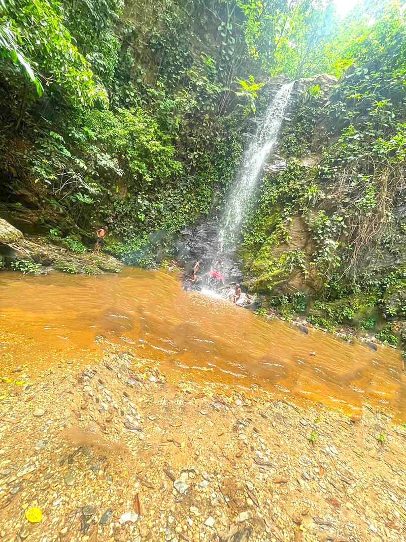
Laboum is a multi-tiered waterfall on the Laboum River inside the park, reached only on foot. The main fall drops about sixty metres into a pool you can swim in, with a game-viewing hide nearby for watching birds and small mammals. Visit Ghana rates the round trip at roughly five hours and a difficulty of three, which is fair: it is a proper walk, not a stroll, and the reward is a cold plunge in forest that few people see.
Tip: Go between August and December, when the falls and the Koue River are at their most dramatic after the rains.
-
Waterfall
3.See the lower falls at Kyabobo
The lower cascade of the Laboum system is the tier most hikers actually reach, and it is generally identified with the lower falls of Laboum waterfall. It makes a satisfying shorter objective than the full sixty-metre drop, with the same forest and riverine birdlife along the way. If your legs or your schedule will not stretch to the full hike, this is the version to ask the guides about at the headquarters.
Tip: Ask at the park headquarters which tier is currently reachable — trail conditions change with the rains.
-
Attraction
4.Start at the park headquarters and entrance
The headquarters is where a Kyabobo visit actually begins. It sits about five kilometres off the Ho–Temale Road at Nkwanta, turning at the park sign, and it is where you arrange guided hikes, sort out mountain-bike rental and get a realistic picture of trail conditions. The site is landscaped, with a campsite next to it that has showers and flush toilets. Treat this as your first stop, not an afterthought.
Tip: Local taxis can cover the five kilometres from the main road to the visitor centre if you arrive without your own transport.
-
Attraction
5.Cycle around Breast Mountain
The park has two mountain-biking trails, and bikes can be rented at the headquarters. The classic loop runs around Breast Mountain with a stop for refreshment at Keri village before you head back — Visit Ghana puts it at about four hours at a moderate difficulty. It is a good way to cover ground and see the transition from farmland into protected savannah without committing to a full day on foot.
Tip: Check the bikes over before you set off; spares and repairs are not readily available out on the trail.
-
Attraction
6.Visit the Akyode shrine
The Akyode shrine is a traditional site of the Akyode (Kyode) people, recorded as the Akyode paramount site in Nkwanta South. The Akyode are the first settlers of Nkwanta and its environment, a Guan-speaking people whose chiefs hold the title wura and whose paramount seat lies at Shiare. Shrines and sacred groves are part of the cultural landscape around the park, and visiting one with a community guide is the respectful way to understand a living tradition rather than a monument.
Tip: Arrange any shrine visit in advance through the local chief or a community guide, and follow their guidance on dress, photography and where you may walk.
-
Attraction
7.Shop the Nkwanta Town Market
Nkwanta's market is the commercial heart of the municipality and a major Monday market known for yam trading. The town's market area includes a dedicated yam market alongside the main market, and buyers and traders converge from across the country during harvest seasons to purchase in bulk. Even if you are not buying, an hour here explains the region's economy better than any statistic: the scale of the tubers, the loading, the haggling, the food vendors working the edges.
Tip: Mondays are the big day. Go in the morning, keep your bag in front of you, and ask before photographing people.
-
8.Climb to Shiare, the Hanging Village
Shiare is a mountain settlement in the Breast Mountains, part of Nkwanta South Municipality and about a thirty-minute drive from Nkwanta. Its houses are built of rock and clay on terraces along the mountain's contour, which is what earned it the name Hanging Village. The community is Guan-speaking Akyode, reckoned to be around nine centuries old, and it has a waterfall that serves as its water source. It is one of the most striking settlements in the region.
Tip: This is a living village, not a site. Arrange your visit through the local chief or a community guide, and be mindful that the community has been affected by the wider land and chieftaincy tensions in the municipality.
-
9.Walk the Togo border country
For the seriously committed, the park offers multi-day routes through rugged terrain. One walk follows the Koue River along the Togo border, with an overnight stay on a raised platform overlooking the water and a chance to watch forest and water birds — and, occasionally, elephants entering from Togo. Another climbs from Koue along the mountain ridge to a shrine and sacred grove, where you can sleep on a platform and watch bats leave a cave at dusk. These are demanding, guide-dependent trips.
Tip: These routes need proper arrangements and an overnight, so build in a spare day and carry more water than you think you need.
Plan your time
Suggested itinerary
Half a day: market and headquarters
If you have only a morning, spend it in town and at the park gate. Start at Nkwanta Town Market on a Monday if you can, when the yam trade is at its busiest, and give yourself an hour to walk the stalls and the yam section. Then take a taxi the five kilometres from the Ho–Temale Road turn-off to the Kyabobo National Park headquarters and entrance, where you can talk through trail options, see the landscaped grounds and book a guide for a longer visit. If time allows, add the short walk to the lower falls rather than attempting the full Laboum hike.
Nkwanta Town Market→Kyabobo National Park Headquarters and Entrance→Kyabobo Lower Waterfalls
One day: Kyabobo on foot
Give a full day to the park. Be at the headquarters for opening, confirm your route and guide, then walk the ridge trail in the south-east corner up to a peak on the Breast Mountains for the view towards Lake Volta. Break for lunch in the shade, then take the trail to Laboum Waterfall and swim in the pool at its foot, watching for birds and small mammals from the hide. If you would rather not walk twice, swap the afternoon for a rented mountain bike and the loop around Breast Mountain with a stop at Keri village.
Kyabobo National Park Headquarters and Entrance→Kyabobo National Park→Laboum Waterfall→Kyabobo Lower Waterfalls
Two days: park, village and shrine
Day one follows the one-day plan, ending back in Nkwanta for the night. On day two, drive the thirty minutes to Shiare in the Breast Mountains and climb into the Hanging Village, where rock-and-clay houses sit on terraces cut along the mountainside. With a community guide arranged in advance, visit the Akyode shrine and learn something of the Akyode, the Guan-speaking people recorded as Nkwanta's first settlers. Finish with a slow afternoon at Nkwanta Town Market before you travel on.
Kyabobo National Park Headquarters and Entrance→Kyabobo National Park→Laboum Waterfall→Akyode Shrine→Nkwanta Town Market
Seasons and festivals
When to go
The park is open year-round, but the walking is at its best after the rains. Visit Ghana notes that the Laboum waterfall and the Koue River are most dramatic from August to December, when the water is high and the forest is green. That window also overlaps with the yam harvest, when the region's markets are at their liveliest and buyers converge from across the country. The drier months that follow make for easier trails and clearer views from the ridges, though the falls are thinner. The villages of Shiare, Koue and Kylinga and their shrines can be visited at any time with community guides, after arrangements have been made with the local chief. Note that a ban on festivals inside Nkwanta township has been in force since November 2023 under regional security measures, so confirm the current position before planning a trip around any celebration.
- Gyogyi (Akyode yam festival) · Annually, traditionally around the yam harvest
- Gyogyi is the annual yam festival of the Akyode people, with Gyogyible as the climax of the individual towns' celebrations. The Oti Regional Coordinating Council describes its origin as an acknowledgement of the blessing of yam and of the Brukum Stool. Visit Ghana notes that Nkwanta and the communities around the park are known for yam festivals held each year around August and September. Because festival celebrations in Nkwanta township have been restricted under the security measures in place since November 2023, check locally before travelling for a specific date.
- Yam harvest market season · Harvest seasons, with early varieties from around July
- Not a festival as such, but the busiest time to see Nkwanta's market doing what it does. The Oti Region is known as Ghana's yam basket, and Nkwanta is one of the markets at the centre of the trade, with buyers and traders converging during harvest seasons to buy in bulk. Early-maturing varieties dominate sales from around July, and Nkwanta South produced more yam than any other district in the region in 2024.
Access
Getting there and around
Nkwanta is reached by road. Visit Ghana puts the park at about 400 kilometres from Accra, and the practical approach is by trotro: services run from Accra, Hohoe and Tamale, with a change at Bimbila for travellers coming from the north. From the main Ho–Temale Road at Nkwanta, turn at the Kyabobo National Park sign and follow the road for five kilometres to the park headquarters. Local taxis may be available for that last stretch from the main road to the visitor centre. Once you are in the municipality, shared taxis and trotros connect Nkwanta with surrounding towns and villages, and Shiare is about a thirty-minute drive from Nkwanta. For the park itself, walking is the point — trails are the only way to reach Laboum Waterfall and the mountain routes — and guides, plus mountain-bike rental, are arranged at the headquarters. Road conditions in the region are variable, and poor feeder roads are a long-standing complaint locally, so allow generous time for any journey and avoid planning tight connections.
Good to know
Before you go
Kyabobo is a genuine wilderness park with limited infrastructure, so come self-sufficient and come prepared to be flexible. Bring sturdy footwear, long trousers for the trails, sun protection, insect repellent, a hat and more water than you think you need; there is little shade on the ridges and no shops on the routes. Arrange guides and bikes at the headquarters rather than setting off alone, and treat stated hike times as estimates. Cash is essential — do not rely on cards in Nkwanta. The municipality has experienced serious inter-communal conflict over land and chieftaincy, with a festival ban in Nkwanta township in force since November 2023 and a peace process under way; check the current situation with local authorities or your hosts before travelling and follow their advice. At shrines, sacred groves and in villages such as Shiare, ask permission before photographing people or sites, dress modestly, and accept that some places may be closed to visitors. Learn a greeting, be patient with arrangements, and remember that the communities around the park are not exhibits.
FAQ
Questions travellers ask about Nkwanta
Where is Nkwanta and how do I get there?
Nkwanta is the capital of Nkwanta South Municipality in Ghana's Oti Region, in the north of the former Volta Region near the Togo border. It is reached by road, with trotros from Accra, Hohoe and Tamale (changing at Bimbila from the north), and the park is about 400 km from Accra.
How do you pronounce Kyabobo?
Visit Ghana gives the pronunciation as CHAY-a-bobo. Wikipedia renders it CHA-bo-bo. Either way, the stress falls at the front.
How big is Kyabobo National Park?
Sources differ. Wikipedia and Herit360 give the park as 360 square kilometres, while Visit Ghana's page states 220 square kilometres. It was established in 1993, with boundaries adjusted until they were fixed in 1999.
Can I see elephants in Kyabobo?
Elephants are recorded in the park and occasionally enter from neighbouring Togo, but sightings are not guaranteed. The wildlife you are more likely to encounter includes buffalo, kob, warthog, bushbuck, duikers, baboons and the rock hyrax, the park's emblem.
When is the best time to visit Laboum Waterfall?
Visit Ghana advises that the waterfall and the Koue River are most dramatic after the rains, from August to December. That period also coincides with the yam harvest and the busiest market season.
What is the Hanging Village near Nkwanta?
Shiare, known as the Hanging Village, is a mountain settlement in the Breast Mountains about a thirty-minute drive from Nkwanta. Its houses are built of rock and clay on terraces along the mountain's contour, and it is the paramount seat of the Akyode people.
Is it safe to visit Nkwanta?
Nkwanta South has seen serious inter-communal conflict over land and chieftaincy, and a ban on festivals in Nkwanta township has been in force since November 2023, though a peace dialogue and pact were reached in March 2026. Check the current situation with local authorities or your hosts before travelling and follow their advice.
Keep exploring
More destination guides
Sources for this guide (14)
- Kyabobo National Park — Wikipedia
- Kyabobo National Park — Visit Ghana
- Kyabobo National Park — Visit Ghana (attractions)
- Nkwanta South Municipal Assembly — About the Assembly
- Nkwanta South Municipal District — Wikipedia
- Kyode people — Wikipedia
- Shiare — Wikipedia
- Oti Region — Wikipedia
- Tourism and Culture — Oti Regional Coordinating Council
- Kyabobo National Park, Oti region, Ghana — Ghana-Net
- Kyabobo National Park — Herit360
- More Than a Crop: Why Yam Remains Oti Region's Economic Lifeline — Ghana News Agency
- Three factions in Nkwanta South hold peace dialogue — Ghana News Agency
- Nkwanta South MCE tours Nkwanta market and Kpassa lorry station — Modern Ghana
Written September 29, 2026 from these sources and reviewed by the VisitGhana.app team. Confirm practical details locally before travelling.